Introduction
rHEALPixDGGS is a Python 3 package that implements the rHEALPix discrete global grid system (DGGS). rHEALPix stands for rearranged Hierarchical Equal Area isoLatitude Pixelization. HEALPix [Gorski2005] is an equal-area pixelization of the sphere from astronomy whose pixel centres lie on rings of constant latitude. rHEALPix [GRS2013] rearranges its planar projection so that the globe unfolds into the six equal squares shown below.
The projection maps points between the ellipsoid and the plane, preserving area. The grid system is built on top of it. Each square is divided into N_side by N_side equal children, and so on recursively, so every point on Earth lies in one cell at each resolution and all cells of a resolution have the same area. A cell is named by an identifier such as P40: a letter for its base square and one digit per level. Parents, children, neighbours and the topological relations between cells are computed from these identifiers. The projection is implemented in rhealpixdggs.pj_rhealpix; the grid system is rhealpixdggs.dggs.RHEALPixDGGS, with parameters N_side, the placement of the polar squares (north_square, south_square) and the ellipsoid’s central meridian (lon_0).
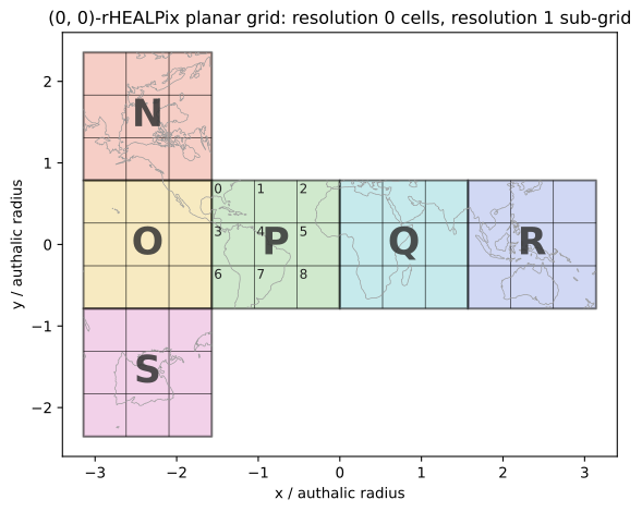
Fig. 2 The (0, 0)-rHEALPix planar grid: the six resolution 0 cells unfolded from a cube, each subdivided into its resolution 1 sub-grid. Cell P’s children are labeled with their SUID digits, so e.g. the cell in its lower-right corner is P8.
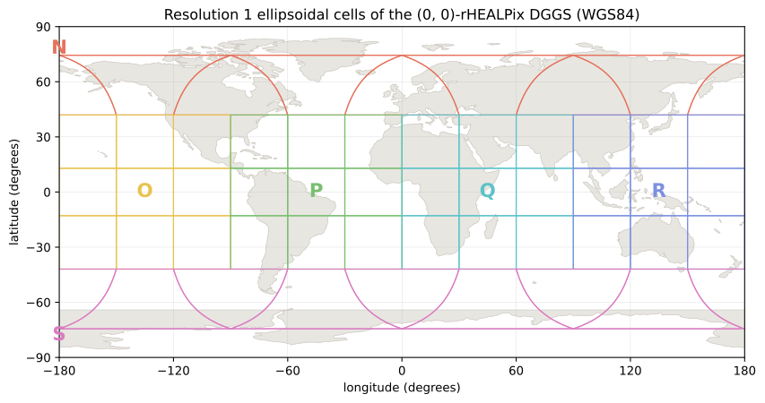
Fig. 3 The same resolution 1 cells mapped back onto the WGS84 ellipsoid, in longitude-latitude coordinates: quad cells in the equatorial band; dart, skew-quad, and cap cells in the polar regions.
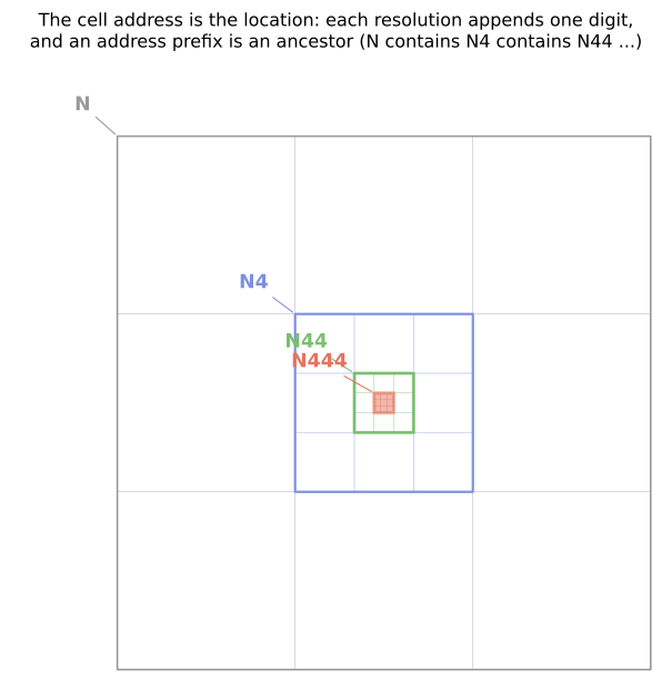
Fig. 4 The cell hierarchy: each cell subdivides into an N_side-by-N_side
grid of children (here N_side = 3), and a cell’s address (its SUID)
is its parent’s address plus one digit – N contains N4 contains N44
contains N444. An address prefix is always an ancestor, which is
what makes the predicates contains_cell, within and the
compact_cells function pure string operations.
This documentation assumes you are familiar with the rHEALPix DGGS as described in [Gibb2016] (with full mathematical detail in the preprint [GRS2013]) and with basic Python usage as described in The Python Tutorial.
Requirements
NumPy >=2.0 Base N-dimensional array package
SciPy >=1.11 Fundamental library for scientific computing
Pyproj >=3.6 Python interface to the PROJ cartographic library
Shapely >=2.1 Manipulation and analysis of planar GEOS geometries
Installation
The package is available on PyPI, the Package Index from where it can be installed as follows:
pip install rhealpixdggs
rHEALPixDGGS is also available for download from the Bioeconomy Science Institute’s GitHub repository https://github.com/manaakiwhenua/rhealpixdggs-py from where the latest version can be cloned.
Usage
To use rHEALPixDGGS after installing it, start a Python session in the directory where you downloaded the modules and import the modules. Here are some examples. For a list of all methods available, see the application programming interface (API) in the following chapters.
Using the ellipsoids and projection_wrapper Modules
The ellipsoids module implements functions and constants dealing with ellipsoids of revolution (which include spheres but not general triaxial ellipsoids).
For brevity hereafter, the word ‘ellipsoid’ abbreviates ‘ellipsoid of revolution’.
The module projection_wrapper implements a wrapper for the map projections of ellipsoids defined in pj_healpix, pj_rhealpix, and Pyproj.
projection_wrapper uses the HEALPix and rHEALPix projections
defined in pj_healpix and pj_rhealpix, this package’s own pure-Python
reference implementations of the projection formulas in [Gibb2016], rather
than the C implementations in the PROJ library (reachable through Pyproj).
This keeps all grid computations identical regardless of the installed PROJ
version. To use PROJ’s implementations instead, edit the
HOMEMADE_PROJECTIONS line in projection_wrapper.
Import all the classes, methods, and constants from the module:
>>> from rhealpixdggs.projection_wrapper import *
>>> from rhealpixdggs.ellipsoids import *
Create an ellipsoid, say, one with major radius 5 and eccentricity 0.8:
>>> ellps_1 = Ellipsoid(a=5, e=0.8)
>>> print(ellps_1)
ellipsoid:
    R_A = 4.322001171188888
    a = 5
    b = 2.999999999999999
    e = 0.8
    f = 0.4
    lat_0 = 0
    lon_0 = 0
    radians = False
    sphere = False
The names of the ellipsoid attributes agree with the names of the PROJ.4 ellipsoid parameters.
For example, R_A is the authalic radius of the ellipsoid, the radius of the sphere that has the same area as the ellipsoid.
By default, angles are measured in degrees. If you prefer radians, then do:
>>> ellps_2 = Ellipsoid(a=5, e=0.8, radians=True)
>>> print(ellps_2)
ellipsoid:
    R_A = 4.322001171188888
    a = 5
    b = 2.999999999999999
    e = 0.8
    f = 0.4
    lat_0 = 0
    lon_0 = 0
    radians = True
    sphere = False
Some common ellipsoids are predefined as constants.
>>> print(UNIT_SPHERE)
ellipsoid:
    R = 1
    R_A = 1
    a = 1
    b = 1
    e = 0
    f = 0
    lat_0 = 0
    lon_0 = 0
    radians = False
    sphere = True
>>> print(WGS84_ELLIPSOID)
ellipsoid:
    R_A = 6371007.180918476
    a = 6378137.0
    b = 6356752.314245179
    e = 0.081819190842621
    f = 0.003352810664747
    lat_0 = 0
    lon_0 = 0
    radians = False
    sphere = False
>>> print(WGS84_ELLIPSOID_RADIANS)
ellipsoid:
    R_A = 6371007.180918476
    a = 6378137.0
    b = 6356752.314245179
    e = 0.081819190842621
    f = 0.003352810664747
    lat_0 = 0
    lon_0 = 0
    radians = True
    sphere = False
Ellipsoid instances are parametrized by geographic longitude and latitude with the central meridian at lon_0. (lat_0 is kept for PROJ name compatibility and must be 0: recentring in latitude is not a rotation of the ellipsoid and is not supported.)
Project some points of the ellipsoid using the HEALPix and rHEALPix projections:
>>> from numpy.testing import assert_allclose
>>> h = Projection(ellps_1, 'healpix')
>>> rh = Projection(ellps_1, 'rhealpix', north_square=1, south_square=2)
>>> assert_allclose(h(0, 60), (0.0, 3.35127855017803), rtol=1e-14, atol=0) == None
True
>>> assert_allclose(rh(0, 60), (0.0, 3.35127855017803), rtol=1e-14, atol=0) == None
True
>>> assert_allclose(h(0, 70), (0.864006732389895, 4.258498514443268), rtol=1e-14, atol=0) == None
True
>>> assert_allclose(rh(0, 70), (-0.864006732389895, 4.258498514443268), rtol=1e-14, atol=0) == None
True
Using the dggs Module
The module dggs implements the rHEALPix DGGS and various operations thereupon.
Import all the classes, methods, and constants from the module
>>> from rhealpixdggs.dggs import *
Create the (0, 0)-rHEALPix DGGS with N_side=3 that is based upon the WGS84 ellipsoid:
>>> from rhealpixdggs.ellipsoids import WGS84_ELLIPSOID
>>> E = WGS84_ELLIPSOID
>>> rdggs = RHEALPixDGGS(ellipsoid=E, north_square=0, south_square=0, N_side=3)
>>> print(rdggs)
rHEALPix DGGS:
    N_side = 3
    north_square = 0
    south_square = 0
    max_areal_resolution = 1
    max_resolution = 15
    ellipsoid:
        R_A = 6371007.180918476
        a = 6378137.0
        b = 6356752.314245179
        e = 0.08181919084262149
        f = 0.0033528106647474805
        lat_0 = 0
        lon_0 = 0
        radians = False
        sphere = False
Some common rHEALPix DGGSs are predefined as constants; WGS84_002 is
the same grid with N_side 2 (see Choosing N_side):
>>> print(UNIT_003)
rHEALPix DGGS:
    N_side = 3
    north_square = 0
    south_square = 0
    max_areal_resolution = 1
    max_resolution = 1
    ellipsoid:
        R = 1
        R_A = 1
        a = 1
        b = 1
        e = 0
        f = 0
        lat_0 = 0
        lon_0 = 0
        radians = False
        sphere = True
>>> print(WGS84_003)
rHEALPix DGGS:
    N_side = 3
    north_square = 0
    south_square = 0
    max_areal_resolution = 1
    max_resolution = 15
    ellipsoid:
        R_A = 6371007.180918476
        a = 6378137.0
        b = 6356752.314245179
        e = 0.08181919084262149
        f = 0.0033528106647474805
        lat_0 = 0
        lon_0 = 0
        radians = False
        sphere = False
>>> print(UNIT_003_RADIANS)
rHEALPix DGGS:
    N_side = 3
    north_square = 0
    south_square = 0
    max_areal_resolution = 1
    max_resolution = 1
    ellipsoid:
        R = 1
        R_A = 1
        a = 1
        b = 1
        e = 0
        f = 0
        lat_0 = 0
        lon_0 = 0
        radians = True
        sphere = True
Pick a (longitude-latitude) point on the ellipsoid and find the level 1 cell that contains it
>>> p = (0, 15)
>>> c = rdggs.cell_from_point(1, p, plane=False); print(c)
Q0
Find the ellipsoidal (edge) neighbors of this cell
>>> for (direction, cell) in sorted(c.neighbors(plane=False).items()):
...     print(direction, cell)
east Q1
north N2
south Q3
west P2
Find the planar (edge) neighbors of this cell
>>> for (direction, cell) in sorted(c.neighbors('plane').items()):
...     print(direction, cell)
down Q3
left P2
right Q1
up N2
Find all the level 1 cells intersecting the longitude-latitude aligned ellipsoidal quadrangle with given northwest and southeast corners
>>> nw = (0, 45)
>>> se = (90, 0)
>>> cells = rdggs.cells_from_region(1, nw, se, plane=False)
>>> for row in cells:
...     print([str(cell) for cell in row])
['N2', 'N1', 'N0']
['Q0', 'Q1', 'Q2', 'R0']
['Q3', 'Q4', 'Q5', 'R3']
Compute the ellipsoidal shape and ellipsoidal nuclei of these cells. The
nucleus is the point under the centre of a cell’s planar square, the point
the grid indexes by; a cell’s published position, its direct position in
the sense of OGC Topic 21, is its area-weighted centroid, which
rhp_to_geo reports
>>> expected_results = [
...    [
...        (0.0, 58.52801748206219),
...        (44.999999999999964, 58.52801748206219),
...        (90.0, 58.52801748206219)
...    ], [
...        (14.999999999999998, 26.490118751439734),
...        (45.0, 26.490118751439734),
...        (74.99999999999999, 26.490118751439734),
...        (105.00000000000001, 26.490118751439734)
...    ], [
...        (14.999999999999998, 0),
...        (45.0, 0),
...        (74.99999999999999, 0),
...        (105.00000000000001, 0)
...    ]]
>>> for i, row in enumerate(cells):
...     for j, cell in enumerate(row):
...         print(cell, cell.ellipsoidal_shape, assert_allclose(cell.nucleus(plane=False), expected_results[i][j], rtol=1e-15, atol=0) == None)
N2 dart True
N1 skew_quad True
N0 dart True
Q0 quad True
Q1 quad True
Q2 quad True
R0 quad True
Q3 quad True
Q4 quad True
Q5 quad True
R3 quad True
Create the (0, 0)-rHEALPix DGGS with N_side = 3 that is based on the WGS84 ellipsoid.
Rotate the DGGS about the polar axis so that New Zealand sits in the middle of
an equatorial face: face edges and polar dart cells lie on the meridians
lon_0 + k * 90, so a lon_0 45 degrees west of Auckland keeps them clear
of the country. (Recentring in latitude is not supported; Ellipsoid rejects
a nonzero lat_0 because a latitude shift is not a rotation of the ellipsoid
and would break the equal-area property.):
>>> p = (174, -37)  # Approximate Auckland lon-lat coordinates
>>> from rhealpixdggs.projection_wrapper import *
>>> E = Ellipsoid(a=WGS84_A, f=WGS84_F, radians=False, lon_0=p[0] - 45)
>>> rdggs = RHEALPixDGGS(E, N_side=3, north_square=0, south_square=0)
>>> print(rdggs)
rHEALPix DGGS:
    N_side = 3
    north_square = 0
    south_square = 0
    max_areal_resolution = 1
    max_resolution = 15
    ellipsoid:
        R_A = 6371007.180918476
        a = 6378137.0
        b = 6356752.314245179
        e = 0.08181919084262149
        f = 0.0033528106647474805
        lat_0 = 0
        lon_0 = 129
        radians = False
        sphere = False
>>> print(rdggs.cell_from_point(1, p, plane=False))
Q7
References
Robert Gibb, The rHEALPix discrete global grid system, IOP Conference Series: Earth and Environmental Science 34, 012012, 2016.
Robert Gibb, Alexander Raichev, Michael Speth, The rHEALPix discrete global grid system, preprint, 2013. Gives the full mathematical detail of the system this package implements.
Krzysztof M. Górski, Eric Hivon, Anthony J. Banday, Benjamin D. Wandelt, Frode K. Hansen, Mstvos Reinecke, Matthias Bartelmann, HEALPix: A Framework for High-Resolution Discretization and Fast Analysis of Data Distributed on the Sphere, The Astrophysical Journal 622(2), 759-771, 2005. Introduces the isolatitude ring structure that rHEALPix inherits and the spherical harmonic transform built on it.
David Bowater, Emmanuel Stefanakis, The rHEALPix Discrete Global Grid System: considerations for Canada, Geomatica 72(1), 27-37, 2018. Discusses cell shape and orientation in the polar region and how to choose lon_0 and the polar squares for a region of interest.
Related reading:
Mark R. Calabretta and Boudewijn F. Roukema, Mapping on the HEALPix grid, Monthly Notices of the Royal Astronomical Society 381(2), 865–872, 2007. Defines the HEALPix projection that rHEALPix rearranges.
Charles F. F. Karney, On auxiliary latitudes, 2023. Source of the authalic latitude power series used in
utils.auth_lat.