PAN-NZ Data Improvement
PAN-NZ Data Improvement
These guidelines set out the minimum data requirements for protected area datasets to be included in the Protected Areas Network of New Zealand (PAN-NZ) national dataset.
Aotearoa New Zealand has a rich and diverse network of protected areas, including national parks, scenic reserves, QEII covenants, and local government-managed reserves. Representing these areas consistently at a national level depends on the quality and compatibility of the source data.
PAN-NZ is a national initiative that brings together datasets from local and central government and NGOs. By providing your data in a consistent and accessible format, you can help to:
These guidelines are not intended to create unnecessary work. They aim to reduce duplication of effort, streamline integration, and simplify updates in future. Often, small changes to metadata or access settings can make a dataset far more usable at the national level.
By aligning your data with these guidelines, you are contributing to a nationally significant layer that supports conservation, planning, and transparent decision-making across Aotearoa.
These guidelines are currently in draft form and we welcome your feedback.
If you have suggestions, corrections, or would like to propose improvements, please see the Contribute / Contact section for information on how to get involved.
Your input helps ensure the guidelines remain practical, inclusive, and widely applicable across Aotearoa.
Below are the minimum requirements that a protected area dataset should meet to be included in the national PAN-NZ dataset.
To ensure datasets can be easily discovered, evaluated, and integrated into the national dataset, data holders should meet the following access-related criteria.
Open licensing enables datasets to be used nationally without legal uncertainty. It allows PAN-NZ to be openly published, shared, and integrated with other public data.
Each dataset must have a clearly stated data licence that permits reuse and redistribution in derivative form. The preferred licence is Creative Commons Attribution 4.0 (CC BY 4.0). The licence should be included in the dataset’s metadata and clearly visible at the point of access. This aligns with the New Zealand Government NZGOAL framework, which encourages open release of public data to maximise value and reuse.
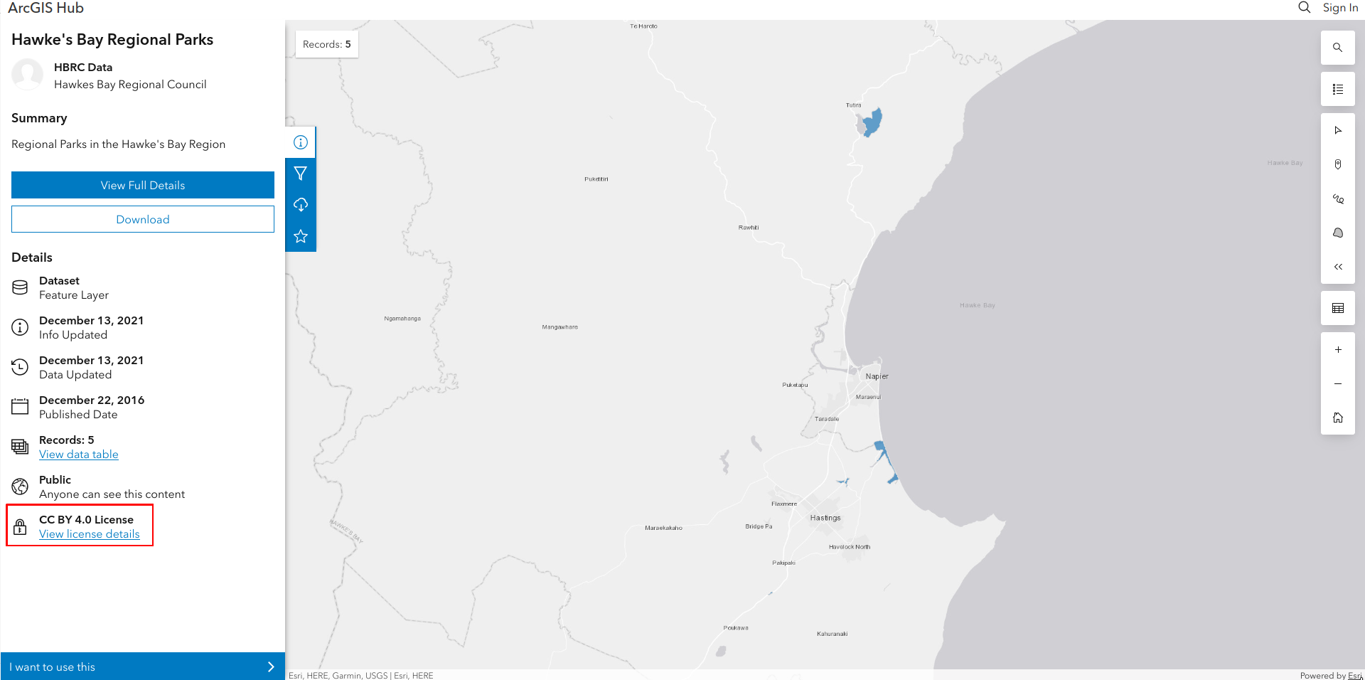 Above: Example of a protected area dataset with its licence clearly displayed at the point of access, ensuring it can be reused and shared. Example as per
Hawke’s Bay Regional
Parks
Above: Example of a protected area dataset with its licence clearly displayed at the point of access, ensuring it can be reused and shared. Example as per
Hawke’s Bay Regional
Parks
Below are common licensing issues that prevent datasets from being included in the national PAN-NZ data layer. When licensing excludes a dataset, the protected areas it contains may not appear in the national PAN-NZ layer, limiting their visibility to policymakers, researchers, and the public.
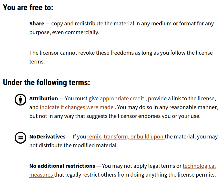
Above: The CC BY-ND (No Derivatives) licence which excludes
derivatives as a result of remixing, transforming or building upon the original data. Such licences
exclude datasets from PAN-NZ
PAN-NZ prioritises datasets that are easy to access and incorporate. Preferred methods are listed below in order of suitability:
Metadata provides essential context to help users understand and correctly interpret your dataset. While a full ISO 19115 metadata record is ideal, PAN-NZ requires only a minimal metadata profile containing the following fields:
| Field | Description |
|---|---|
| Title | Name of the dataset |
| Description | Short explanation of the dataset’s purpose and contents |
| Creator / Owner | The organisation responsible for maintaining the dataset |
| Contact Email | A contact person for questions or updates |
| Licence | The licence applied to the dataset |
| Date Updated | Most recent date of data revision or publication |
| Geographic Extent | Area covered (e.g. “Tasman District”, or bounding box in WGS84) |
| Projection | Spatial reference system (e.g. NZTM2000 or EPSG:2193) |
| Format | API protocol or file format that the data is shared in (e.g. OGC WFS, ESRI REST, GeoPackage, Shapefile) |
To ensure your protected area datasets are visible and accessible to PAN-NZ and other users, we encourage the following good practices:
By following these steps, your dataset becomes easier to discover, interpret, and integrate into national frameworks, contributing to a clearer and more complete picture of protected areas across Aotearoa.
PAN-NZ aims to develop an open and accessible national dataset of protected areas while fully complying with the Privacy Act 2020. Public-facing datasets should not include any personal or identifying information about individuals. This includes, but is not limited to:
Maintaining privacy from the outset helps ensure that PAN-NZ remains a trusted, inclusive, and legally compliant platform for sharing environmental information.
The section below lists the minimum set of attributes needed to describe a protected area in a way that’s meaningful and usable within PAN-NZ.
To support consistent integration across New Zealand, PAN-NZ defines a minimal schema for describing protected areas. This schema outlines the essential attributes each dataset should contain to be eligible for inclusion in the national dataset.
The table below specifies the minimum attributes required for each protected area record. While we expect many datasets to contain additional information, only the fields listed here are considered necessary for national aggregation. Additional attributes may still be valuable locally but will not be carried into the PAN-NZ core dataset.
Note: While we define preferred field names, your dataset does not need to use these exact names. The key requirement is that the information is present. Field mappings can be applied during aggregation to align your dataset with the PAN-NZ schema.
| Field Name | Description | Required |
|---|---|---|
| protected_area_id | A unique and persistent identifier for the protected area. | Yes |
| name | The commonly used or official name of the protected area. | Yes |
| legislation_act | The name of the legislation under which the area is protected. | Yes |
| legislation_section | The specific section or clause of the act relevant to the protection. | Yes |
| protection_type | The type or category of protection (e.g., reserve, covenant, national park). | No |
| local_reserve | The purpose of reserves under Section 22 (government purpose reserve) and section 23 (local purpose reserve) of the Reserved Act 1977 | No |
| start_date | The date the protection came into effect | Yes |
| end_date | The date the protection was formally removed | Yes |
Further detail on each field is provided in the following sections, including how they support national integration and classification (e.g. IUCN category mapping).
| PAN-NZ Schema Name | Required |
|---|---|
| protected_area_id | yes |
Each protected area record should include a persistent, unique identifier. This ensures records can be tracked across updates and matched across systems.
| PAN-NZ Schema Name | Required |
|---|---|
| name | yes - where recorded |
If the managing entity assigns names to protected areas, they should be included. Providing a recognisable name helps users refer to each area via a common name, rather than relying on IDs alone.
This can also assist in linking protections to other sources of information that rely on names as common identifiers, such as management plans that refer to protected areas by name.
| PAN-NZ Schema Name | Required |
|---|---|
| legislation_act | yes - where not implicit |
Datasets should specify the legislative act under which each area is protected. This field provides the legal context needed to confirm protection status and supports classification into IUCN categories. Without this information the degree to which the area is protected cannot be communicated.
In some cases, however, the legislation may be implied from the dataset context. For example, a dataset titled “Regional Parks” may be understood to refer to areas protected under Section 139 of the Local Government Act 2002. For this reason, this field is marked as required where not implicit.
Best practices:
Examples of common protected area related legislation can be found in the below section.
| PAN-NZ Schema Name | Required |
|---|---|
| legislation_section | yes - where not implicit |
Where applicable, include the specific section in the act that establishes the legal protection. This field provides the legal context needed to confirm protection status and supports classification into IUCN categories.
The preferred format is: “S<Section Number> <Section Name>”. For example: “S19 Conservation Park”.
The below table provides an example of a subset of the legislative acts and sections that are commonly captured by PAN-NZ
| legislative act | legislative section |
|---|---|
| Conservation Act 1987 | S19 Conservation Park |
| Conservation Act 1987 | S20 Wilderness Area |
| Conservation Act 1987 | S21 Ecological Area |
| Conservation Act 1987 | S22 Sanctuary Area |
| Conservation Act 1987 | S23a Amenity Area |
| Conservation Act 1987 | S23b Wildlife Management Area |
| Conservation Act 1987 | S25 Stewardship Area |
| Local Government Act 2002 | S139 Regional Park |
| Queen Elizabeth II National Trust Act 1977 | S22 QEII Open Space Covenant |
| Reserves Act 1977 | S17 Recreation Reserve |
| Reserves Act 1977 | S19-1a Scenic Reserve |
| Reserves Act 1977 | S19-1b Scenic Reserve |
| Reserves Act 1977 | S23 Local Purpose Reserve |
| Reserves Act 1977 | S17 Recreation Reserve |
| Wildlife Act 1953 | S14 Wildlife Refuge |
| Wildlife Act 1953 | S9 Wildlife Sanctuary |
| Wildlife Act 1953 | S14A Wildlife Management Reserve |
Above Table: The above table provides an example of a subset of protected area legislative acts and sections
| PAN-NZ Schema Name | Required |
|---|---|
| reserve_purpose | No - only for areas under section 22 and 23 under the Reserves Act 1977 |
Under the Reserves Act 1977, areas protected under Section 22 (Government Purpose Reserve) and Section 23 (Local Purpose Reserve) should include the specific purpose of the reserve in the reserve_purpose field. These reserves can serve a wide variety of functions, ranging from wetland management to infrastructure-related uses such as river bank protection. Capturing this detail helps clarify both the intent and the strength of protection provided. Including this information is important for understanding the role and significance of each protected area within the national context.
The reserve purpose text should be formatted in title case (e.g., Wetland Management, River Bank Protection) and should not include the act name or section number. This ensures consistency across datasets and allows the purpose to be clearly understood without repeating legal references already captured in other fields.
| PAN-NZ Schema Name | Required |
|---|---|
| protection_type | No |
This field is not mandatory, but some datasets include a type attribute that describes the nature of the protection. When legal act and section details are missing, this field can help infer the legislative basis for protection.
Using this field alone is not the preferred method, as it can introduce ambiguity or lead to incorrect classifications. However, it may still be useful when no formal legal references are available.
The protection type should describe the form of protection, such as “Scenic Reserve,” “Wildlife Sanctuary,” or “Recreation Reserve.” During data aggregation, PAN-NZ may use these values to assign likely legal act and section. For example, if a record is typed as “Wildlife Sanctuary” but lacks legal references, PAN-NZ may infer it corresponds to Section 9 of the Wildlife Act 1953.
| PAN-NZ Schema Name | Required |
|---|---|
| start_date | Yes (where available ) |
The date on which the protected area status formally came into effect. This should reflect the date the legal mechanism or decision establishing the protection was enacted or gazetted. Where possible, this should match the date stated in the relevant legal notice, gazette, or formal decision document. Including this field helps users understand the duration and history of the protection, which is useful for reporting, legal validation, and historical analysis.
The start date format should be as defined by ISO 8601 (i.e. YYYY-MM-DD)
| PAN-NZ Schema Name | Required |
|---|---|
| end_date | Yes (where available ) |
The date on which the protection status formally ended. This field should only be populated if the area is no longer protected under the recorded mechanism. If the protection is still active or intended to be permanent, this field should be left blank. Including an end date supports reporting and analysis of historical protections.
The end date format should be as defined by ISO 8601 (i.e. YYYY-MM-DD)
Protected areas submitted to PAN-NZ must include valid spatial geometry to ensure they can be accurately mapped and integrated into the national layer.
In terms of spatial data, PAN-NZ requires the following:
We recognise that not all datasets will initially meet all aspects of these guidelines. Some datasets may be missing legal references or may be incomplete. These datasets are still valuable.
Even if your data is not yet fully compliant, we encourage you to share it with us. Early contribution allows us to:
You do not need to wait for a perfect dataset. PAN-NZ is designed to evolve and improve over time, your early contribution is a key part of that process.
In summary, datasets that contribute to the PAN-NZ national layer should meet the following criteria:
By meeting these requirements, data holders help ensure their protected areas data can be accurately integrated and nationally accessible through PAN-NZ.